


Environment and Geography
The present-day Diaguita people are located in in the Huasco and Choapa river valleys of Chile’s Norte Chico region, where they have officially constituted as indigenous communities, based on their former existence as “Indian towns” established during the colonial period. Most of the population that self-identifies as Diaguita lives in the Upper Huasco River basin, particularly around the Tránsito River and Huasco Alto, in the municipality of Alto del Carmen. Other Diaguita communities are located in Vallenar and Freirina (Huasco Bajo), and further south in Chalinga, in the Choapa Valley.
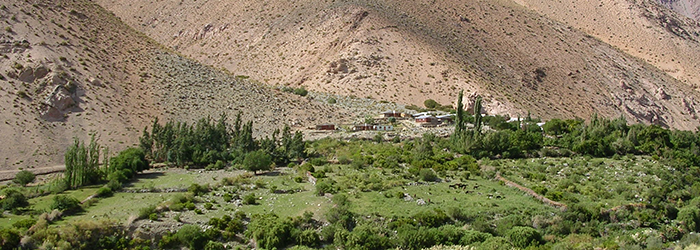
The zone of Huasco Alto is a foothills region with a semi-arid climate. Geographically it features steep, narrow valleys and high mountain peaks. The valley is watered by the Tránsito River, whose tributaries include the Valeriano, Cazadero, Conay and Chollay rivers, which flow down from high in the Andes. Its indigenous inhabitants have their settlements and grow their crops on the valley’s broad terraces. The Huasco River emerges at the confluence of the Tránsito and Carmen rivers then flows down to the sea. The territory of Huasco Alto varies in altitude from 1500 to more than 6000 m above sea level, with a climate ranging from cold desert to Alpine tundra. Its vegetation includes a pre-Andean tier (1500–2700 m a.s.l.) covered by herbaceous plants and cacti on the slope, valley bottoms and low lying ravines. Somewhat higher (2700–3500 m a.s.l.) is the sub-Andean tier with grasses and bushy scrub, while the Low Andean tier (3500–4250 m a.s.l.) includes a variety of grasses, low shrubs and cushion plants. The final ecological tier is the subniveal or Andean desert (4250–4500 ma.s.l.), where sparse grasses are the only vegetation.
The Diaguita community of Chalinga is located in the valley of the same name in the middle reaches of the Choapa River, near the town of Salamanca. The Choapa River emerges in the Andes Mountains at the confluence of three of its tributaries—the Totoral, Leiva and Del Valle rivers. Downstream, in the foothills, it receives the waters of the Cuncumén and Chalinga rivers. This zone has a lowland marginal desert climate that is characterized by a maritime influence, winter precipitation, clear skies, low humidity and a high daytime-night time temperature variation.